The BIG idea:
The BIG Smack in the Face:
I WAS WRONG
Lesson 1: Expect the weather NOT to cooperate.
Day 1:

We began our journey with an awesome climb up Hankey mountain.

The weather was great at around 80 to 85 degrees, sunny, and not too humid. We quickly learned that climbing with all of our gear was not such an easy task, especially when considering the steep grades on Hankey Mountain. A bigger issue, though, was Francine's pack. It was too big, and there was really no way to secure it better to fit her small frame. As we climbed, I watched her pack creep over to her left shoulder and sit there. It looked painful.
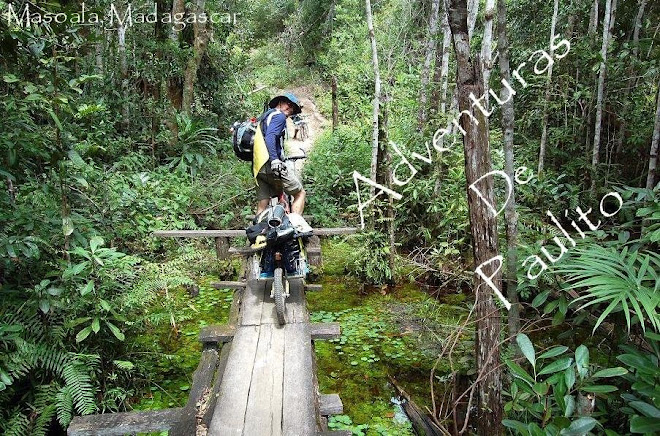
 Notice something wrong with this picture?
I knew this would be an issue for the entire trip, but all we could do at that point was try to minimize the issue.
Upon reaching the crest of Hankey Mountain, we ate a couple of bagels with pepperoni and cheddar cheese and took in the view.

We headed down Dowell's Draft for what should have been a screaming descent. Unfortunately, Francine's gear kept her from bombing the descents. Her pack would ride up her back (still against her left shoulder) preventing her from looking up as it was coming into contact with her helmet. So, she basically had to creep down the mountain. I didn't really have any problems with my pack or gear, but my pack didn't weigh 1/3 of my body weight. So I would bomb a section, wait, bomb, wait... I felt bad that Francine couldn't enjoy the downhills since that is the best part, but it was too late to fix.
Lesson 2: Get fitted by a pro before purchasing a pack for bike touring.
We returned to gravel and rode a short section on US 250 to the next single track trail,
Georgia Camp Hollow.
 According to the National Geographic topo maps, Georgia Camp Hollow appeared easier than the climb up Hankey with only a moderate grade. In reality, the grade was generally fine for a well groomed, hardpacked, dirt trail. However, most of Georgia Camp Hollow was not well groomed, hardpacked, or dirt. It was heavily overgrown with
stinging nettles and other herbaceous fun
mixed with loose baby heads and short steep impossibilities.

 See what I mean?!
Are your legs itching and burning yet??
 Lesson 3:
 If you'll be riding in George Washington National Forest, WEAR LONG SOCKS!!
Honestly, it's a great trail that I would love to tackle with long socks and no gear on my back... Unfortunately, the heavy packs made lots of the trail completely unridable for us.
So, we walked a few miles to the fire road at the top.

At the intersection,we took a left turn uphill for some more climbing. After a mile or so of steep climbing, we reached the Shenandoah Mountain Trail(SMT) at 3,700 ft!

The SMT follows the ridgeline of Shenandoah Mountain and includes the Southern Traverse. This was our first time on this section of the SMT and it was a great ride!
Finally!
The ridgeline trail was super fast and fun!

We had planned to ride the entire SMT and Camp at the base of Little Mare on the first day; however, with the late start, we were running out of daylight (and I was out of water). So, we completed a few miles of the SMT before descending down the west side of the mountain on Benson Run Road. About 1.5 miles down the mountain, we found a nice perennial stream to filter water and there were a couple of decent choices for camping spots. We filled our packs and bottles with fresh water, set up camp, and cooked an awesome meal (Mountain House Lasagna).

I'm not so sure Francine was enjoying it, as she told me, "I don't like this part". She was referring to the stinking, non-bathing, and bugs everywhere biting us. In fact, the bugs were so thick and persistent that one of us had to swat them away while the other would take a bite of food. Then we'd switch. This continued until we had finished our dinners. It was pretty damn funny. Really, I'm sorry I didn't get any video footage.
As soon as we finished eating, we scrambled into the tent to safety. That night, we reevaluated the course, trying to make sure we would be prepared for the next day.

DAY 1 STATS:
5 hours and 25 miles of riding, 6,500 feet of climbing, several miles of hike-a-bike, lots of stinging nettles, massive amounts of biting flies.
Day 2:
We froze over night, which lowered our responsiveness to the morning sunlight; additionally, we camped on the western side of the mountain, so we missed out on the early morning sun. Again, we started riding too late.
Lesson 4: Camp on the east side of the mountain, where the sun shines early.
We started the climb back to the SMT around 9:30am, arriving in about 40 minutes. The next 11 miles or so was sweet and fast ridgeline riding along the Southern Traverse!


The last (and the only previous) time we rode the Southern Traverse trail, the trail was covered with deep leaves that render much of it unridable. This time, however, the trail was clear and for the most part free of debris. We dropped down the mountain to SR627, a gravel road, and saw the trail continuing across the street. We took the trail, and hiked almost all of the 2 to 3 mile trail . Somewhere, the trail just disappeared, so we followed the trail on the GPS until we dropped onto SR678, an asphalt road.
 So, was that a trail??? What the ??
The asphalt section continued for 5 to 6 miles before we started our climb on gravel to the Little Mare trailhead. We were looking forward to an relatively easy climb up Little Mare as the map rated the trail as "Easy"! We really needed a trail we could actually climb without having to jump off and push.
We filled our Camelbaks at Thompson Creek, climbed SR683, and arrived at the Little Mare trailhead at around 4pm.
The trail was 6 miles long, all climbing.
We planned to complete the climb and descend to a known campsite near Douthat State Park, or just keep riding into Douthat (bypassing the hike-a-bike up Middle Mountain).
As luck would have it, the first mile of Little Mare trail was double track and sloped gently uphill, giving both Francine and I the idea this trail would be mostly rideable and a needed break from hike-a-biking.
However...
When the trail became singletrack, it seemingly jutted straight up the mountain! Like clockwork, we cranked as hard as possible until our bikes stopped moving forward, jumped off, and uddered groans as we pushed up and up.
After a couple miles of this (intermixed with short sections of rideable terrain), the trail became a bit more rideable.
To give some perspective, when I say more rideable, I mean that we were both in our granny gears with a cadence of...uhh 40.
Well, shit happens, right?!
 Apparently, there are plenty of Bears on this mountain...
They must be BIG bears!!!
Along came the chill of the late afternoon and it was approaching 6pm. Francine wanted to push on and get down from the mountain (believe me, I did too), but I had a sense we wouldn't make the crest by dark. I was also freezing, completely soaked through with sweat, and tired.
It seems like Francine and I get ourselves into all kinds of trouble being determined, adventurous-minded people (e.g., nearly freezing on Big Levels near Sherando while biking on snow during the winter without the proper gear).
Sometimes, you should be safe and not sorry, and I felt this was one of those times.
So, we camped on the ridgeline at 2,800 feet.
We found a spot right next to the trail and set up camp.
Again, we had some delicious dinners by Mountain House (I really should be sponsored). This night we ate Mexican rice with Chicken and Pasta Primavera! Damn that stuff is good! It was warm that night, and we finally got some nuch needed sleep!
Day 2 STATS:
37 Miles, 6,000 feet of Climbing, more hike-a-bike, lots of bear poop.
Day 3:
We awoke, thoroughly rested, to the distant sounds of thunder. Since we were on the ridge, we had a rare opportunity to make a phone call. So, I called my dad to see if he'd check the radar. It wasn't looking good. He said there was a severe thunderstorm over Roanoke that was headed due North, directly toward us. To make matters worse, the forecast was looking bleak as well. The previously forecasted "Isolated" thunderstorms became "Scattered" thunderstorms over the next three days. This news gave us motivation to get going to avoid being caught on this ridge with no place to take cover. It also made us concerned with the remainder of our tour.
We packed quickly and began climbing Little Mare again (it should really be called Dead Man's Ridge or something more ominous). We climbed for about 30 minutes before the storm hit.
Lightning was striking all around us!!
We dropped our bikes
Ran down the side of the ridge about 30 feet
And took cover beneath a small sheet of plastic.
The storm continued to pound on us with lightning strikes shocking the mountains and ridges all around us. We just sat there, getting soaked and cold for nearly an hour and a half...
(See Lesson 1)
When the lightning finally decided to move North, we jumped back on the bikes and crept up to the crest of Little Mare at around 3,500 feet. This section of the trail was mostly wet rock, which made riding difficult.
Remember, we were carrying nearly 40 lbs of gear, each.
The 500-foot descent to Little Wilson Creek at the end of the Little Mare Trail was technical, rocky, and steep-
A
SWEET
section of trail.

The rain was becoming a light drizzle at this point, so we took a short break at Little Wilson Creek. After crossing the creek, we hike-a-biked again to 3,700 feet on Brushy Mountain to reach the long descent to FR194 (an alternate route we decided to take since the weather was uncooperative).
 Hey Buddy! If we lick your back, will we puke orange?
Sorry... A.D.D. moment... Where was I?
The descent was again technical and rocky, and I took a nice header (i.e. I flipped over the handlebars and tossed my bike down the hill) trying to descend down some slippery rocks. Francine took a couple of nice spills as well.
I'd rather not land on my ass when I fall on rocks, but I guess it's better than my face!
MY busted ASS PIC not inserted due to graphic nature.
We dropped down Brushy Mountain Trail (456) and veered left at trail 620 descending to FR194. What an awesome trail! Technical as hell, steep, rocky, narrow, overgrown with blueberry and mountain laurel...
What more can you ask for?
 Well, a pack that fits, I guess... Sorry Francine...
I really enjoyed the downhill and after a few miles, we were back on roads. We took FR194 to SR629 and rode into Douthat, straight to the campground showers!!
After our showers, we decided rather than continue to Blacksburg with three more days of thunderstorms on different mountain ridge trails (the remainder of the tour was mostly ridgeline riding), we'd try and work a transfer back to Blacksburg (my car was waiting there).
I made a couple of calls and discovered that my friend, Aaron, 
was on route to Blacksburg from Vermont.
When I asked him if he could take a short detour to give us a hand, he said,"I think I may have passed it already... Where is Douthat? I'm at Lexington right now."
SWEET!!!
I said,"Dude, take a left!" and he met us at Douthat in about a half hour!!
AWESOME TIMING!!!
Thanks Again, Aaron!
So, we bailed. It was a hard decision, but I think it was the right one. We'll come back to ride the section from Douthat to Blacksburg sometime soon...
Day 3 STATS:
18 miles of riding/hike-a-biking, ~2,000 feet of climbing, 1.5 hours of sitting under a tarp in a crazy storm...and we bailed.
The next day, we worked in a hiking trip up to Dragon's Tooth on the Appalachian Trail.
 What an amazing view!
and A great trail! Good Times...
4 comments:
Dang, Francine is MY HERO. You're both a little crazy, but I enjoyed reading about your adventures!
Great stuff dude. I noticed 2 things in those nice pictures. #1 you need to re-center your stem & front wheel. It’s off to the right. #2 you need to put a ring on Queen Francine’s finger sooner than later. The tale sounds harsh and somewhat miserable at times yet she is smiling and mostly happy looking in every single picture. That’s a keeper bro, awesome. I hope to slip in on the part 2 of this story. Let me know when it goes down. Until then thanks for the read.
Peace,
Metro
Uhhh ... what was lesson #1 again?
Interesting article, keep it up guys, I'm just wondering if what type of tire you are using in that kind of terrain.
------------------------------
Fender Flares | Bushwacker | Bestops| Discount-autocar-parts | 4wheelonline | All about car
Post a Comment